For anyone seeing our planet for the first time from a satellite’s perspective, worries about water might be the last thing to cross their mind. Had we first seen the planet that way; we would probably have named it ‘Water’ rather than ‘Earth.’
Looking at its clouds and ice sheets as well as its expanses of water, we would also see from that perspective that we live on a planet at just the right distance from its star to let water exist in its solid, liquid and vapor states. A few million miles farther from the sun, toward Mars, and our water would all be frozen in its solid state. A few million miles closer to the sun and the water would all be a gaseous cloud mass suffocating the planet. In neither of those situations could life as we know it exist; all life on the planet depends on water in its liquid state – but all land-based life also depends on water in its vaporous state. And water’s solid state plays an essential role in getting liquid water to a place like the Colorado River region.
It’s also worth noting that all of us land-based life forms depend entirely on a very small portion of the planet’s water. Most of Planet Earth’s water – 97 percent – is too ‘salty’ with dissolved solids for land-based life. We need freshwater, all of which is originally distilled as vapor from the salty oceans.
But at any given time, only about 2.5 percent of Earth’s water will have undergone that transformation to freshwater. And two-thirds of that is still ‘frozen assets’ in glaciers and ice sheets – although all of those are in the process of shrinking in the warming times. These are remnants of much larger masses of ice and snow that have dominated the planet for most of the past two million years – a gray age of ice and deserts as huge amounts of the planet’s limited freshwater came as snow that just piled up rather than melting to the liquid state living things need.
The third of the planet’s freshwater not piled up in ice sheets and glaciers is mostly groundwater, an important but invisible resource, accessible for plants through roots and for humans through wells. But the visible liquid water we think of as our basic water resource – all of the rivers and streams, lakes and wetlands on earth – is only about 0.3 percent, three-tenths of one percent, of the planet’s total water.
So how does that miniscule portion of earth’s liquid water get distributed to all of us land-based life? More specifically – how does any of it get here, to the headwaters of the Gunnison and Colorado Rivers?
Freshwater gets distributed around the planet’s land areas in a complex dance between liquid water and water vapor. The greatest sources begin as vapor distilled from the tropical oceans, carried aloft on rising warm air. This does not happen evenly; some areas of the ocean are hotter than others, and the hotspots move around on the oceanic currents. There’s no dependable consistency in how and where this pure water is boiled off of the salty sea; sometimes, some places, the vapor rises in squall-size quantities; the other extreme is the coalescing of massive ‘atmospheric rivers’ of water vapor rising on a 200-mile front. That’s what Southern California and the Colorado River region experienced in late December – not even on the radar early in the month.
But as the vapor rises away from the warm ocean surface, it cools, and the moisture recondenses as liquid water and falls as precipitation – much of it right back into the ocean. But prevailing winds carry some of that vapor over the planet’s land masses where the uneven land surfaces initiate the vapor-liquid dance.
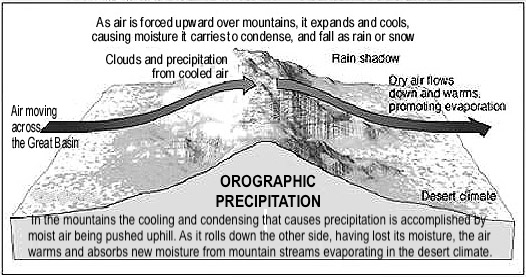
We’ve all seen the grade-school ‘Water Cycle’ graphic that shows an ocean shore with arrows of water vapor rising off of the ocean, and moving over the land, which gradually slopes up through farmland and a river town with smokestack industry, to steeper forested land and then mountains. As a mass of warm wet air is pushed upslope by prevailing winds, it cools with altitude; its moisture condenses and falls as orographic precipitation, rain or snow caused by the upslope movement.
The majority of the water that falls in the Colorado Rockies comes originally from the Pacific Ocean – a long journey of almost a thousand miles. That simplified water-cycle graphic only gets precipitation coming off the Pacific Ocean up the coastal mountains of California – but that is less than a tenth of the way to the Rockies. So obviously a lot depends on what happens in the water cycle after that initial ‘orographic lift’ of distilled water straight from the ocean.
The second part of the water cycle comes when the cooled air mass goes over the top of the mountain and begins to flow down the lee side – still cooled enough to lose some of its moisture as precipitation there, although the majority of what it lost fell on the windward side. As the air mass descends, it begins to warm up again, and as it warms its begins to absorb whatever moisture it encounters, creating a ‘rain shadow’ of dry land.
But running through that dry land are streams flowing from what previous storm systems had deposited high on the leeward mountain slopes, and as those streams flow down into the warm – often quite hot – valleys, they begin to give up water vapor through evaporation. Which the dried air mass also coming down into the valley absorbs, restoring some of what it lost in the orographic lift over the mountain. Call it ‘recycled’ Pacific water: there is a kind of dance going on between the vaporous and the liquid water, vapor becoming liquid or solid (snow) in the orographic process, while on the other side of the mountain, water from previous storms is going from solid (snowpack) to liquid to vapor again, to again be picked up by the moving air mass and carried on to the next orographic adventure….
That ‘dance’ happens a lot as air masses journey from the Pacific Ocean to the Rocky Mountains. Once over the coastal ranges where they lose considerable moisture, they drop into California’s hot Central Valley where they restore quite a lot of their moisture – then up and over the Sierras, even higher and copping a lot of the air mass’s water; then down into the Great Basin for the bulk of the journey on to the Rockies.
The Great Basin is a ‘cold desert,’ essentially a huge orographic rain shadow, but into it more than forty streams flow from the surrounding highlands that create the Basin – some of them substantial rivers as they come off their mountain origins, like the Truckee River that flows through Reno. But all of those rivers just gradually disappear as they flow out into the Basin. Some of their water sinks into the ground, but a lot of it evaporates into the dry air, vapor which the east-moving air mass, significantly depleted by the lift over the Sierras, picks up as it bumps along over the smaller mountains of the basin-and-range country.
And that is what eventually arrives at the Southern Rockies: an air mass carrying only a fraction of the original Pacific water vapor it started out with, but augmented by recycled water vapor from previous precipitation events along the long journey. And the Rockies are so high, and in the winter so cold, that they receive a substantial deposit of orographic precipitation. It does not have as much moisture as it had when it came ashore, in California or along the Northwest coast, but it has lost and gained and lost and gained enough, in the liquid-vapor water dance, to create a respectable headwaters for the Colorado River.
Longtime observers of Upper Gunnison weather have noticed patterns in the way that all-important winter snowpack comes – or doesn’t come. Winter Pacific storms that come inland north of California tend to drop most of their Southern Rockies bounty north of an east-west line running along Grand Mesa and the Elk Mountains (the ranges just north of Crested Butte), but often have little or no snow for the Gunnison River Basin, and even less for the San Juan region southward. The best storms for southwestern Colorado and the Gunnison Basin come inland south of San Francisco – sometimes even south of the Sierras, meaning more for the Rockies and San Juans. These local observations match up roughly with more sophisticated information about the El Niño/La Niña water-temperature oscillations in the Pacific that ultimately move the jet streams around far above us.
We also occasionally get the remnants of big storms that move up the Rio Grande and Arkansas River Basins from the Gulf of Mexico. Our summer ‘monsoon’ cycle – maybe a fifth of our water supply in a good summer – is frequently driven from that southeasterly direction. And an occasional powerful ‘polar vortex’ will push down over the Rockies from the north with a little dry snow and a lot of bitter cold – a reminder that, like New England oldtimers say, ‘The Pleistocene isn’t over; the glaciers just went back for more rocks.’
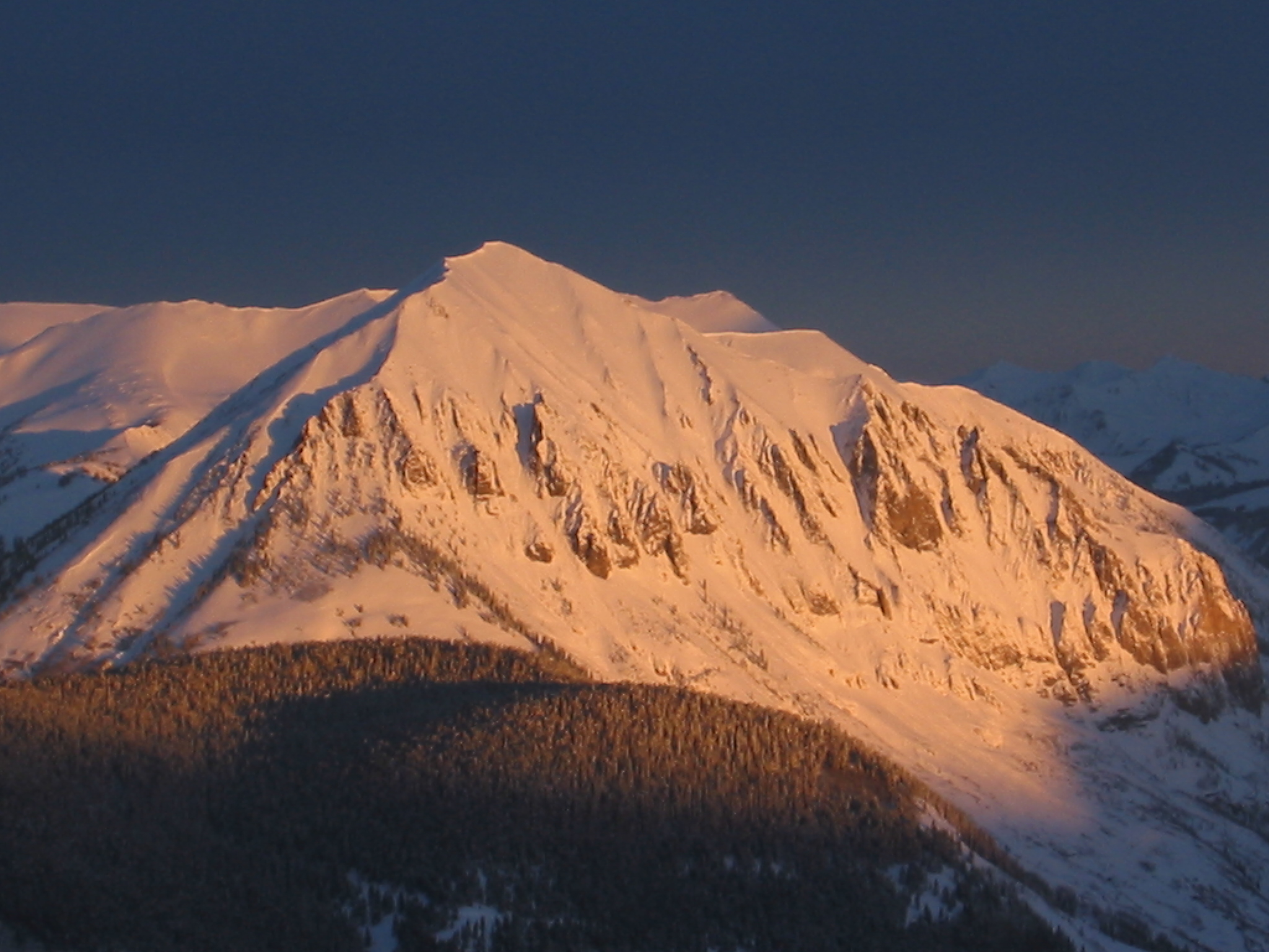
But our water primarily originates in climate action from the west, as described above, and the most of it by far falls in the high country above 8,000 feet elevation. The City of Gunnison, at 7,700 feet elevation, is a desert town with around 11 inches of natural precipitation a year; Crested Butte, a mere 20-plus air miles to the north but 1,300 feet higher, gets more than twice that, and the mountains above Crested Butte get three or four times more precipitation than Gunnison.
How much water does the Upper Gunnison River get from the weather created by this regional climate? A study of the Colorado River Basin, released in 2020 by the University of Colorado’s Western Water Assessment, estimated that 170 million acre-feet of precipitation on average falls annually over the Colorado River basin – roughly 55 trillion gallons. More than half of that – ~97 million acre-feet – falls in the 15 percent of the river basin’s land above 8,000 feet elevation – headwaters basins like the Upper Gunnison.
But – and here’s a mystery as well as an indisputable fact – of that 170 million acre-feet that falls on the Colorado River Basin, only around 10 percent, 14-17 million acre-feet, actually makes it into the Colorado River as liquid freshwater.
What happens to the other 90 percent of ‘our’ precipitation? We’ll look at that in a couple weeks.
But meanwhile – remember the Anthropocene: what is climate change doing, or likely to do, to the way our water gets here?
The consensus of the science community seems to be that the Southwestern U.S. will have less water in the future, while the Northwest and Upper Midwest may get more, although there is no certainty about that, or where the line between less and more might fall. It obviously depends a lot on what happens in the complex interactions between the atmosphere and the Pacific Ocean. We know that ambient temperatures are going to continue to rise as our emissions into the atmosphere continue to rise; the capacity of the atmosphere to hold water increases with temperature, and there is more heat energy driving the tropical rise of warm wet air. This could mean more ‘atmospheric rivers’ of vapor rolling over the land.
But the warm wet air rising is part of a great cycle, the Hadley Cell, whose other side is rained-out dry air descending in powerful high-pressure ridges – like the ‘Ridiculously Resilient Ridge’ that plagued the West Coast from 2012 to 2015: a long high-pressure ridge offshore of dry descending air that diverted Pacific storms far north and south of their usual tracks.
There is concern about expansion of the ‘subtropical desert region,’ a permanent region of dry lands just north and south of the tropics globally, created by the high-pressure columns of descending dried-out air on the ‘down’ side of the Hadley Cell mentioned above. The Sonora and Mojave Deserts in the lower Colorado River region are part of that global desert region: will that region begin to expand northward in the more energized atmosphere of the Anthropocene? Bringing to the Southern Rockies a climate more like Central Arizona or New Mexico?
Probably better than second-guessing nature on this would be to get our heads together now about dramatically reducing our greenhouse gas emissions over the next couple decades. Stop digging!


