The previous post here ended with the observation, from the 2020 Western Water Assessment Colorado River science study, that around 170 million acre-feet of water fall on the Colorado River Basin – but only 14-17 million acre-feet end up in the actual river.
Where does the other 90 percent go? And a corollary question: for such a water-stressed river basin, is there any way to get some of that lost water in the river?
We observed earlier that Planet Earth is at just the right distance from the sun for water to exist as a solid, liquid and vapor; recall too that virtually all land-based life depends on it vaporizing from the salty ocean (leaving the salts behind), and then falling over the land as freshwater precipitation, liquid and solid. And the transformations between states are a function of temperature, solar intensity and wind – which means that in a time of rising ambient temperatures, water’s predilection for the vaporous state is enhanced.
This predilection for the vapor state is first noticed immediately after precipitation arrives as snow in the high alpine zone of the headwaters, above the forest zones. It is usually windy there, and as the wind moves snow around in the unsheltered rock-and-ice reaches, often in direct sunlight, some of the snow sublimates – goes straight from the solid state to vapor – as the wind and sun break up the snow crystals.
More sublimation happens when the snow falls on the trees below ‘timberline,’ usually between 10,000-11,000 feet elevation in the Southern Rockies. When snow falls on the subalpine (spruce-fir) or montane (pine) forests, it is sheltered and shaded from sun and wind by trees – if it manages to fall through the tree branches to the ground. But if the snow gets captured on branches, then the sun heats the dark branches under the captive snow and sublimates it, even if the air temperature is below freezing. Where the canopy is dense and a lot of snow is intercepted, this sublimation process can ‘disappear’ as much as a third of the snow that falls on the forests that are the dominant ecosystems in the headwaters region, below the treeless alpine zone. (We will look more closely at these forest ecosystems in future posts here, but for today our interest is only in their impact on water supply.)
Historically, on average, the winter snowpack that survives sublimation reached its peak sometime in early April. That doesn’t mean the snow stops falling or wintry weather ends; as T.S. Eliot said, April can be a cruel month – all the way into late May. But at some point in April, the snowpack usually starts to turn to water.
For several years, my family and I lived in Gothic, Colorado, as caretakers for the Rocky Mountain Biological Laboratory, eight miles north of Crested Butte and five miles beyond the end of plowed-out civilization. Through the winter, we lived at ‘surface level’ rather than at road level, packing down rather than shoveling trails to the springbox where we got our water, the outhouse, the woodpile, et cetera. But once the spring melt really set in, the snowpack began to ‘rot’ – water from the surface trickling down through it – and our packed trails became something between treacherous and hilarious if we tried to use them in the warm part of the day.
The world turning to water was full of surprises even for someone out on skis. Small streams of running water would form up under the snowpack, below sun-facing slopes melting quickly. The skier might suddenly crash through the entire ‘rotted’ snowpack, his skis going all the way to the ground, where the stream began filling his boots while a ton or two of soggy snow caved in on top of the skis. The only way out was to thrash around in the mess to create a bathtub of slush that would eventually allow you to work back up to the surface.
One of two things could happen to the water from the melting snow: it could sink into the ground, or run off in sheets and trickles gradually coalescing into streams. Which it does is a function of three factors: the slope of the land, the nature of the soil and cover vegetation on the land, and how fast the sun and temperature are driving the melting. When the slope is steep, or the soil is thin and loose, or the temperature and sun are speeding the melting (or all three), a majority of the liquid snowmelt water runs off in streams. In the arid West, most of the human population below the headwaters prefers that a lot of the water come down like that as ‘runoff,’ passing through the forests into either irrigation ditches or storage reservoirs – but not so fast as to cause flooding outside of the constructed water control systems.
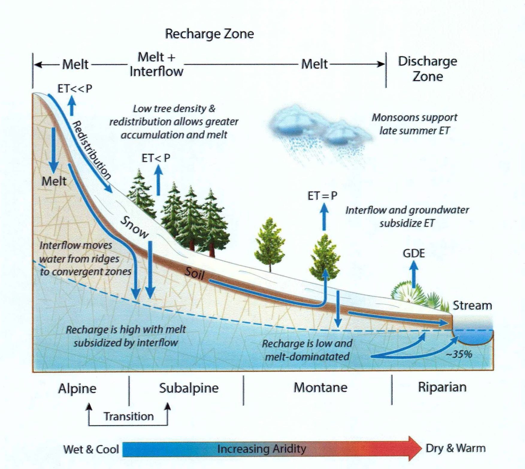
Things get more complex for the water that sinks into the ground, however, as this diagram from a scientific paper by Crested Butte hydrologist Rosemary Carroll shows:

As the snow melts, the portion that sinks into the ground passes into a layer of soil on top of the mountain’s solid but usually porous and fractured rock mass – sometimes with a thick layer of broken ‘cobble’ below the soil. This is the root zone for the forest above, and the trees that are ‘awake’ and getting back into the process of growing will drink from the water soaking in, sucking up the water in long cohesive molecular cell-to-cell chains that carry it to every leaf of every tree. The tree actually only uses about five percent of the water it carries to its highest leaves for nutrition and ‘internal functions’ like photosynthesis; the rest is transpired back into the atmosphere as vapor (‘ET,’ evapotranspiration, in the graphic).
Transpiration is as essential for tree health as perspiration on a hot day is for us, and has a similar cooling function for the trees, but it does convert huge quantities of liquid water back to atmospheric vapor not far from where the precipitation fell. A mature tree in either the subalpine or montane forests might transpire10-20 gallons a day, depending on tree size and temperatures, which doesn’t sound like a lot – until you look at a tree-covered mountainside. If a forest is overstocked with mature trees (the case in many of our forests), there is often not enough water for the trees to drink what they need. That also leaves them with not enough fluid to ‘pitch out’ the insects and diseases that are always present probing for weakness in trees.
Water in the ground that is not used in the root zone by the trees or other plants passes on down through the unsaturated ‘interflow’ zone of soil and rock, until it encounters the water table, below which the rock is saturated with groundwater (blue area in graphic), which slowly moves downslope laterally, nudged along by the weight of new water coming in above. Carroll’s research, in Copper Creek, above Gothic, shows that most of the groundwater recharge comes in the high alpine zone, and the upper subalpine zone where the spruce and fir are less dense and smaller, yet still protecting the snow from wind-and-sun sublimation. Farther downslope, progressively more of the ‘interflow’ water in the near-surface unsaturated root zone is used consumptively by the forest (ET), until consumptive use plus ground evaporation plus tree transpiration are taking nearly all of the ‘interflow’ water, and there is virtually no groundwater recharge after the spring melt, beyond what happened higher above. The ‘groundwater dependent ecosystem’ (GDE) in the valley has to use some of the groundwater and whatever is left of the ‘interflow.’
The groundwater in the saturated zone and some of the ‘interflow’ water as well gradually move downslope to where they interact with the watershed’s stream itself, adding to it if the stream’s flow has fallen below the water table – which it will, once the snow has all melted around mid-summer; at that point, users below the headwaters region, from ranchers to recreators, are glad that some of the snow water soaked into the ground. There will, however, be a lag of from a couple months to half a century before the groundwater completes that underground journey, depending on the nature of the geology it has to work its way through.
Rosemary Carroll’s paper on her Copper Creek study is excellent, and is reasonably accessible to the lay person; email me if you want to a copy to read.
That should more or less answer the question about the disappearance of most of the precipitation that falls over our headwaters watersheds (roughly half of what falls on the entire Colorado River Basin): what isn’t consumed by the forests goes back to the atmosphere. Some foresters have posited the mythic notion that somehow the forests create the water supply – Gifford Pinchot, for example, founder of the U.S. Forest Service, proclaimed that ‘the connection between the forests and the rivers is like that between father and son: no forests, no rivers.’
A more accurate appraisal would be, ‘no groundwater, no forests.’ The forests do play a role in the early development of our rivers, sheltering and shading snowpacks and streams alike from wind and sun. They also anchor the land against the erosive nature of water. And they sequester carbon – until they burn down and put it all back in the atmosphere. But they consume a lot of water to live too, and give a lot away in sublimation and transpiration. The streams that emerge below all the Colorado River’s headwaters regions have, as it were, run a gauntlet of sun, wind and forest.
The water that disappears from a watershed through sublimation, evaporation and transpiration is, of course, not lost from the larger system. It rises as vapor, is pushed upslope by the westerlies, cools and probably recondenses to precipitation eventually, sometimes even in the same headwaters watersheds. We may, in other words, recycle some of our own lost water.
But a bigger lesson to learn from looking at what happens to the vast majority of our precipitation lies in considerations of future forest management – the coming eon when we know that evapotranspiration will be taking even more of the water supply.
We have tended historically to think of forest management in terms of timber – and now, recreation. But the 1897 Forest Service Organic Administration Act states in its second paragraph that ‘no national forest may be established except to improve and protect the forest, or to secure favorable conditions of water flows, and to furnish a continuous supply of timber.’ Nearly all of the headwaters reaches of the Colorado River are designated National Forests under the management of the U.S. Forest Service.
In the Southern Rockies, where it takes a long time to grow a decent sawlog, but water supply is a chronic and growing problem – 90 percent of it coming from the headwaters region – it could be argued that the most important management priority should be ‘to secure favorable conditions of water flows.’
We are in the process, throughout the Southern Rockies, of replacing overmature forests with the ‘next generation’ forest – a forest that will have to live, at the very least, with higher temperatures; this will, if no countering measures are taken, increase water losses through sublimation, evaporation and transpiration – even if precipitation remains relatively constant, which is another unknown. The 40 million people that depend on the Colorado River for some or all of their domestic water, the nation that depends on its irrigated agribusiness for year-round vegetables and fruits, are now depending – whether they realize it or not – on the National Forest managers to ensure something approaching optimal ‘conditions of water flows.’ This is not something that ‘just happens’ if your management priorities are timber and recreation.
The truth is – there is not a body of tried and true practices for ‘securing favorable conditions of water flows’ in a time unfavorable for exposed flowing surface waters; waiting for others to deliver the solution is just a way of deferring the responsibility. There will be more posts here about this. Learning to live with the Anthropocene is not about learning to live without management; we’re already too far into the Anthropocene and our forests to walk away from trying to learn different management for different forests in a different time.
Meanwhile – pray for snow this year; we don’t know yet how to make do with less – forever.


